One year ago, Chantalle and I came to the top of Larch Mountain in Oregon. At Sherrad Point, the view could not be beat. Soon after summiting, two Germans found their way to the top as well. We started to compare hikes and eventually we asked their favorite. Mount Defiance they said without hesitation. We had never heard of it, but Chantalle and I were determined to make it there one day. Finally, after an entire year, she and I arrived at the base of “the mother of all hikes in Oregon”, “the monster”, and the hike that is debatedly “more difficult than summiting Mount Hood”. Oddly enthusiastic and so incredibly unprepared for what was to come, we got out of the car and started towards the trailhead.
The first mile is relatively flat taking us past Cabin Falls, Hole-in-the-Wall Falls, and Lancaster Falls as we walk a portion of the old Scenic Highway. The walk in the park only lasts a short while, however. Don’t let this section fool you. Suddenly, the path rockets upward, switch-backing mercilessly up 1500 feet to a densely forested ridge line. As you climb, putting one foot in front of the other, the thought of blue sky and a viewpoint becomes your motivation. Eventually, your dreams are realized. An excellent panoramic of Mount Saint Helens, Mount Rainier and Mount Adams soothes your forest-weary eyes. Take a moment here to realize how high you have climbed.

The Panoramic of St. Helens, Rainier and Adams
Continue onward and upward. Just because the switchbacks are over for now doesn’t mean the climb is done. You’re not even halfway there! To quote Chantalle during this trying section, “Ever ounce of sweat is worth it!” Bless her heart, she is such a motivational spirit. So I keep panting away, pain shooting through my back as I lean forward, almost parallel to the 40 degree trail. But you must power through. There is a flat portion coming up! I don’t know exactly how long it was, but the level ground was a God-send. Water, water and more water. Breathe in, breathe out. Stretch and keep going. The switchbacks return! Only this time, Chantalle calls them intense! If Chantalle calls something intense, you know that we mortal humans will be dying. And sure enough, she powered through these tight, rocky, incredibly steep switchbacks with little trouble. For me, they were yet another nail in my coffin. For already exhausted legs, this part was killer.
By the time your next viewpoint comes around, you will be at about 4000ft. Don’t be fooled by the look of the trail, you still have 900 feet of elevation left. Continue along the trail until you come to a fork in the road. If you go left, the trail will take you to Warren Lake, then eventually the parking lot. To the right is your goal; the summit of Mount Defiance.

Boulder Fields on the Scenic Route
0.2 miles after the fork, you will see an unmarked trail to the right, which will look questionable at first, but it is a very unique and scenic trail to the top. That’s the way we went. After crossing several boulder fields and catching glimpses of the elusive Mount Hood, one last corner stands between you and the top.

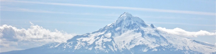
The Summit View
Finally, after more than six miles and nearly 5000 feet in elevation gain, you stand proudly on the summit of the most merciless hike in all of Oregon. Officially the high point in the gorge, Mount Defiance is yours. Sadly, the peak is also home to a noisy and unsightly radio tower. Try to ignore the ugly interruption and look south instead. The plains and rolling hills of Eastern Oregon open up and Mount Hood dominates the horizon. We chose one of the hottest days of the year and Chantalle and I could both feel the sun beating down on us. Nevertheless, we were so tired and sore that we sat on top for about an hour before beginning our long journey home.

Warren Lake
But that isn’t the end of the story. Climbing up 5000 feet is difficult, but going down is far more frustrating. The first part, climbing down to Warren Lake (the left you didn’t take earlier) is actually quite pleasant. In fact, it was very relaxing. We of course stopped by the pretty lake and stayed for a few moments enjoying the variety of scenery. Shortly after, however, begins the plunge. From here on out, the trail drops a thousand feet a mile. With 620 feet in the last 0.3 miles. The trail isn’t very relaxing anymore and each step must be carefully planned so as to avoid any accidental falls. The dust and dirt quickly gives way and if your shoes don’t have much traction, it’s more of a slide than a trail.
Chantalle and I had to keep pushing each other to make it off of the mountain. It wasn’t enough to torture us on the way up, but you must fight your way home too. With more than a mile left, we ran out of water. (I myself brought more than two liters and Chantalle had even more water and yet we still ran dry!)
The last viewpoint on the trail is a point that overlooks the parking lot and stares Dog mountain right in the face. (Did I tell you that we looked DOWN on Dog Mountain for most of this hike?) From this point to the old highway is by far the most mentally challenging part. I was so broken down and worn out all I wanted was to sit down. The downhill was relentless and without any water, we stomped on through dry grass, boiling heat and dusty trails.
Looking down from the trail, we finally saw the old highway and flat ground. After all we had been through we jogged down the last bit and cried out in exhaustion.
We walked slowly back to the car, still standing, still breathing, still living.
Mount Defiance truly is a monster.
